Dane Balk, Mosborough by John Rotherham February 2021
Dane Balk[1] is a site of relatively obscure historical/archaeological interest lying towards the south of Mosborough, straddling the Rotherham Road, between Eckington and Halfway. It was first recorded in a Nineteenth-Century Trade Directory as “a large square intrenchment[2], now very nearly obliterated by the plough, and crossed by the turnpike road to Sheffield” [3].
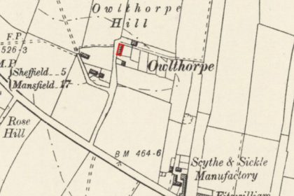
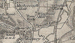
The earliest indication of its approximate location appears in the 1840 Ordnance Survey map (Fig. 1). The land slopes down towards the River Moss at the south. The site’s name is thought to be derived from the Old English denu balca[4], meaning valley ridge or bank, probably influenced by the Old Norse balkr or ridge of land.
Fig. 1. 1840 Ordnance Survey Map, showing the approximate location of Dane Balk, Mosborough.
Personal observations of the site in 1953 and 1965 by Mr W. Askham of Eckington, describe it as “much pitted but without definite trace of an earthwork. There is evidence of rig and furrow in the western half of the area. Nothing of archaeological interest seen”.
There may be associations with a nearby furlong or strip of land called Danehole (Dane Hole)[5] in the Churchfield, part of Mosborough’s medieval three-field system. Churchfield is thought to have been bounded by Hollow Lane, Rotherham Road and Windmill Greenway.
The feature is recorded in the Derbyshire Historic Environment Record (formerly the Derbyshire Sites and Monuments Record)[6].
[1] also occasionally spelled Baulk.
[2] the feature is undated. Hart, C.R., The North Derbyshire Archaeological Survey, p. 116.
[3] Glover, S., The History and gazetteer of the county of Derby, 1831, p. 247.
[4] Cameron, K., Place Names of Derbyshire, Part II, 1959, p. 249
[5] 17th Century references in Garratt, H.J.H., Eckington, The Court Rolls, Vol. IV.
[6] HER No. 4939.
Similar Posts