| Bedlam Square | South of footpath by Peats Farm on South Street, some buildings survive as castle shelter. |
| Bell’s Lane | At the end of the Council houses on the East side of the Common. |
| Bishop’s Tip | A spoil heap from the old pits just off Plumbley Lane |
| Blue Bell Inn | By the Rectory, South Street, Demolished for new housing. |
| Bridle Stile | A very ancient way from Queen Street to Ridgeway Road. |
| Brown Cow Inn | A pub on the North side of Crown Corner now demolished. |
| Brow | The ridge overlooking the Church on the footpath across from Duke Street to the old Grammar School (Westfield). |
| Butcher’s Arms | A pub at the junction of Station Road and High Street, now a disused building, Now an hair dressers 2020 |
| Captain | The first field west of Peats Farm on South Street. |
| Castle (Eckington) | No historical proof of a Castle. |
| Chapel Wheel | Old Mill Dam between Renishaw Golf course and Spinkhill. |
| Coal Pit Lane | An access Road to an old “Bell” pit at the Bridle top |
| Colin Green | Now Queen Street |
| Crown Inn | Opposite the Queen corner of Queen Street and High Street. (Grass land now) |
| Dent Lane | On site of Birley Garden Centre was Dent Main Colliery. |
| Duke William | An old pub on Duke Street, Opposite Claytons butchers. |
| Fitzwilliam Arms | Once an old pub on Mosborough Moor now private residence, part of Savages farm. |
| French Nook | Junction of Duke Street and High Street. |
| Front (the) | The High Street from the ‘Royal’ to the Queen. |
| Gin Banks | Ridge reached by a footpath the leads up to it from Plumbley Farm. |
| Hanging Lea | Woods behind Westfield and Owlthorpe. |
| Hollow | An ancient lane running from High Street, by the side of Mosborough Hall now known as The Hollow Lane. This was once a road through to Rotherham Road. |
| Knowl Hill | Station Road |
| Lambsicks | Grass area bottom of Chapel Street, used to contain the village pond. Also known as Market Street |
| Lion | This was part of the River Moss near Never Fear Dam where children used to paddle. |
| Little Hill | Small hill Road at the bottom of Queen Street adjoining to High Street. In 1700’s Bull baiting took place here. |
| Malthouse Row | From the bottom of Station Road No 32 to the ‘Vine’ |
| Market Street | Now Chapel Street |
| Monkey | A part of River Moss above “The Lion” where children used to swim |
| Moor Hole | From Mosborough Moor over the hill on the east side to the Rear of Wilson garage Birley Moor |
| Nags Head | Later Halfway House approx. site of new roundabout Mosbro’ to Killamarsh Road |
| Nether Misterton | Now School Street |
| Owlthorpe | Off top of Mosbrough Moor Northwards. |
| Peat’s Arches | Old houses on Duke Street, now demolished |
| Piece Stile | Bottom of Stone Street |
| Pingle | An ancient path from Eckington Hall to South Street, Between Elmwood and Eckington Hall |
| Primrose Hill | Top of Chapel Street, grass Bank with white railings, at one time there was Stocks there. |
| Ring Field | A field with two ringed, railed enclosures of trees in the Moss Valley. |
| Rose Hill | A small lane (now disused) on the West side of the top of the Common. |
| Salt Box | A quaint salt cellar shaped House at corner of School Street & High Street, now demolished. |
| Sammy’s | An ancient path off Station Road – led to Beighton surrounded by housing now. |
| Shed Field | At the bottom of the path that starts opposite “The Wheel” and goes down to the River Moss. |
| Smugglers Row | A row of old cottages off High Street where the dentist is now. |
| Summer House | Unusual square looking house on South Street opposite to the Alma Inn and “Croft Nurseries”. |
| Sydney Tavern | Now private residence no 27 Queen Street |
| The Jungle | A part of the footpath from the Bridle to Plumbley. |
| The Lane | Continuation of South Street to Eckington, known locally as “Back Lane” but called Gas House Lane on the ordnance survey maps. |
| The Whins | Gorse bushes off Plumbley Lane, running up to the “Cliffs” from Plumbley Lane Farm. |
| Unwins Well | Near the junction of Station Road and High Street |
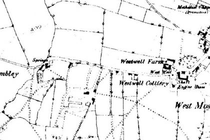
| WestWell | By the Wheel on Plumbley Lane. |
| Windmill | At Plumbley, location unknown. Just off Plumbley Lane on the left hand side, about 200 yards below where the Wheel Public House was. |
| White Bridge | The footbridge over the River Moss near Never Fear Dam. |


