Brief Note on the Early History of Plumbley and Mosborough – By John Rotherham – February, 2018
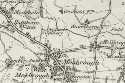
The settlement of Plumbley, lies approximately ¾ of a mile west of the village of Mosborough in South Yorkshire. Sheltered from the north by higher ground, Plumley stands in a hillside location at around 120m. AOD, sharing its contour line with the nearby Mosborough Hall, placing both locations in the same strategic elevation overlooking the Moss and Rother valleys.
Although comprising little more than two or three farms or houses huddled together in an isolated cluster, Plumbley has always enjoyed special status within the Domesday village of Mosborough, which prior to boundary changes, was formerly within the administrative county of Derbyshire.
Mosborough and Eckington have mostly been dismissed as relatively insignificant in archaeological terms. The discovery of flint fragments, including a flint scraper found around 1962 on Ridgeway Moor and several others found north of Eckington, are probably little more than accidental losses or discards rather than evidence of settlement in the immediate area. Ariel photography has enabled the identification from cropmarks of a large circular enclosure with two entrance gaps lying in a field approximately 500m. south of Plumley, which is of unknown date but may also be prehistoric. Visual signs of possible earthworks or early enclosures at Mosborough Hall and in Eckington, identified in the Victorian era, have since been discounted as having little, if any, archaeological significance.
However, this perception may be about to change. In 2013 a programme of archaeological works was undertaken at a site off Staveley Lane in Eckington in advance of development for residential purposes. The excavations revealed a potentially circular ditched enclosure of some 80m in diameter, possibly Iron Age, Romano-British or early medieval, with evidence of iron smelting and forging and some potentially domestic features. Such sites are said to be largely absent from Derbyshire, the only similar site identified so far being at Sherwood Lodge, Bolsover. Further research will be necessary to confirm the veracity of these findings, but if an Iron-Age settlement is revealed, it will confirm early colonisation in the Moss Valley less than two miles south-east of Plumley.
At least one Roman road of uncertain date is thought to run through Eckington and Mosborough, probably a branch from Ryknield Street. Roman roads in North East Derbyshire have often been found to be associated with names containing the Old English straet, and a possible course for a route north of Eckington is suggested by the name of one of Mosborough’s common fields, Streetfield, which lies about a mile to the east of Plumbley.
In 1572, the Eckington Manor Court Rolls record that Francis Hallome surrendered “2a. land in Mosboroughe of which 1a. lay in Streetefeld”. Later, in 1586, John Pynder surrendered a close in the Streetefeld “on the east side of the common way there”. Elsewhere, this “common way”, “hye way” or “queen’s way” is referred to as the “Street Yate”. It is of interest to note that plans in the Fairbank Collection and references in the Court Rolls suggest that Mosborough’s modern High Street equates in its alignment with the “Street Yate” of 1583 (Gate from Gata, which is Old Norse for road or way).
Of more secure date are the Roman artefacts that have been discovered, including a Roman coin found on a footpath leading east from Pipeyard Lane in Eckington, along with four other Roman coins found in the area including a sestertius of Hadrian (17-138 AD), a sestertius of Faustina Junior (161-175 AD) found in 1990 (south-east of Plumbley Hall Farm), a denarius of Domitian (81-96 AD) reported in 1995 (south of Plumley Hall Farm) and a coin of Magnentius (350-353 AD)found in c. 1930. In 2008, a hoard of 10 Roman coins was found alongside Eckington Cemetery from the reigns of Domitian, Trajan (98-117 AD) and Hadrian.
Perhaps the most significant Roman artefacts of all were revealed in a recent discovery at Plumbley Hall Farm in 2012 when of a hoard of five denarii was unearthed from the Roman Republican period – the period before the Roman Empire (509 BC – 27 BC); the first Republican hoard to ever be found in South Yorkshire. Whilst these coins do not constitute evidence of any kind of Romano-British settlement, they do suggest that there may have been something at Plumley that drew the attention of the Roman invaders.
Plumbley’s Anglo-Saxon origin can be inferred from the place-name Plumbley, written as Old English Plume leah, meaningplum wood or clearing, while the name Mosborough, which means “fortified place of the moor”, along with nearby Barlborough, implies that Plumley lay on the suggested boundary line between the Anglo-Saxon kingdoms of Mercia and Northumbria.
The latter part of the 9th Century AD was characterised by Viking invasion and settlement throughout the north of England and penetrating into Derbyshire. The Danelaw system of government, including the measurement of land by the bovate or oxgang, is evident in Plumley deeds and manor court rolls well into the 17th Century. The place-names associated with this wave of settlement often include the Scandinavian element “thorpe”, meaning farm; examples of which abound in the area around Plumbley at Hornthorpe, Westthorpe, Waterthorpe, Hackenthorpe and Owlthorpe. By 944 the Danes had been defeated and the Anglo-Saxons once more gained the ascendency.


